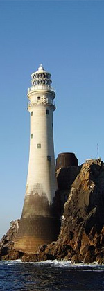
Slyne Head Lighthouse
Appearance
 | |
 | |
| Location | County Galway, Ireland |
|---|---|
| Coordinates | 53°24′00.2″N 10°14′01.6″W / 53.400056°N 10.233778°W |
| Tower | |
| Constructed | 1836 |
| Construction | limestone tower |
| Automated | 1990 |
| Height | 24 metres (79 ft) |
| Shape | cylindrical tower with balcony and lantern |
| Markings | black tower |
| Racon | T |
| Light | |
| Focal height | 35 metres (115 ft) |
| Range | 19 nautical miles (35 km; 22 mi) |
| Characteristic | Fl (2)W 15s |
| Ireland no. | CIL-1990[1][2] |
Slyne Head Lighthouse (Irish: Ceann Léime) is located at the westernmost point of County Galway, about 12 kilometres (7 mi) southwest of Dunloughan, Ireland on the island of Illaunamid. It is maintained by Commissioners of Irish Lights (CIL). There were two lighthouses on this point built in 1836, but only the western one remains active.[3]

See also
[edit]References
[edit]- ^ Slyne Head Lighthouse Archived 8 December 2014 at the Wayback Machine Commissioners of the Irish Lights
- ^ Rowlett, Russ. "Lighthouses of Western Ireland (Ulster and Connacht)". The Lighthouse Directory. University of North Carolina at Chapel Hill. Retrieved 30 October 2015.
- ^ Pelly, Frank. "William Douglass – Designer of Fastnet Lighthouse". Beam 33. Commissioners of Irish Lights. Archived from the original on 13 August 2011. Retrieved 22 October 2010.
External links
[edit]- Slyne Head Lighthouse in Lighthouse Digest's Lighthouse Explorer Database
- photo by Jean Guichard
- Commissioners of Irish Lights

