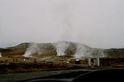
Haukadalur
Haukadalur | |
|---|---|
 View of the Haukadalur valley from Laugarfjall | |
| Coordinates: 64°18′40″N 20°17′2″W / 64.31111°N 20.28389°W | |
| Location | Southwestern Iceland |
| Volcanic arc/belt | West volcanic zone of Iceland |
Haukadalur (Icelandic: [ˈhœyːkaˌtaːlʏr̥] , from Old Norse: Haukadalr [ˈhɔukɑˌdɑlz̠], "hawk dale" or "valley of hawks") is a valley with geothermal activity in Iceland.
Geography
[edit]The shallow valley is at about 100 m (330 ft) above sea level about 110 km (68 mi) to the north-west of Reykjavík.[1] It lies to the north of Laugarvatn lake in the south of Iceland.
Geology
[edit]There is a north-south orientated geothermal area in the valley, of about 1 km (0.62 mi) in width and about 6 km (3.7 mi) long, mainly on the eastern slopes of the rhyolite dome of Laugarfjau that is 187 m (614 ft) high.[2] To the west of the valley is Bjarnarfell at 727 m (2,385 ft) which is a hyaloclastite ridge mainly composed of basalt and some rhyolite.[2] To the north is a shield volcano, Sandfell at 610 m (2,000 ft), which on the valley's horizon.[1] The volcanoes have not been active for over 10,000 years.[3]
Geysers
[edit]Haukadalur is home to some of the best known sights in Iceland: the geysers and other geothermal features which have developed on the Laugarfjall [ˈlœyːɣarˌfjatl̥] rhyolitic dome.[4] The biggest geysers of Haukadalur are Strokkur and Geysir itself, which gave us the word 'geyser'.[1] Strokkur is very dependable and erupts every 4 to 10 minutes,[5] whereas the bigger Geysir nowadays erupts very rarely.[1] There are also more than 40 other smaller hot springs, mud pots and fumaroles nearby.[1] The water source for the geothermal activity may originate from the southern Langjökull ice sheet, about 50 km (31 mi) to the north.[4]
Haukadalur geothermal area was mentioned in written sources around 1294 CE,[6] when new local hot springs were activated by earthquakes,[1] but geothermal activity was present before this.[7] Earthquakes are also known to have activated local geysers in the recent past,[3] including the earthquakes that occurred on 17 and 21 July 2000. Due to the geysers the valley has been a popular tourist attraction since the 18th century.[1]
Nearby attractions
[edit]The Gullfoss waterfall is about 10 km (6.2 mi) to the north in the direction of the Highlands of Iceland, via the beginning of the Kjölur highland road. Along with Gullfoss and Þingvellir, Haukadalur is part of the Golden Circle.
Gallery
[edit]-
Haukadalur in September 2017, Iceland
-
Haukadalur in May 2016, Iceland
-
Haukadalur, Iceland
-
Geothermal area of Geysir
-
Litli Geysir, Haukadalur, Iceland
See also
[edit]- List of cities and towns in Iceland
- List of earthquakes in Iceland
- List of waterfalls of Iceland
- Volcanism of Iceland
References
[edit]- ^ a b c d e f g Pasvanoglu 1998, p. 282.
- ^ a b Pasvanoglu 1998, pp. 282–3.
- ^ a b Pasvanoglu 1998, p. 283.
- ^ a b Jones & Renaut 2021, Geology setting.
- ^ "GEYSIR HOT SPRINGS IN ICELAND". Arctic Adventures. Retrieved 12 November 2023.
- ^ Jones & Renaut 2021, Age of Geysir.
- ^ Jones & Renaut 2021, Conclusions.
Sources
[edit]- Pasvanoglu, S. (1998). "Geochemical study of the Geysir geothermal field in Haukadalur, S-Iceland" (PDF). In Pasvanoglu, S.; Kristmannsdóttir, H.; Björnsson, S.; Torfason, H. (eds.). Geothermal Training Programme Reports 1998. United Nations University. pp. 281–318. Retrieved 29 January 2024.
- Jones, B.; Renaut, R.W. (2021). "Multifaceted incremental growth of a geyser discharge apron – Evidence from Geysir, Haukadalur, Iceland". Sedimentary Geology. 419: 105905. doi:10.1016/j.sedgeo.2021.105905. ISSN 0037-0738.


